2017 bicycle tour around the Cascade Mountains

June 26th I said goodbye to the SOB's and drove my Vanagon with Surly Touring bike and loaded panniers to the Jacobsen cabin on Elger Bay, Camano Island, Washington State.
Camano Island is shown in red on the map about sixty miles north of Seattle.

The Jacobsen Cabin.

Friends and family arrive and we have a great 4th of July catching

and eating Dungeness Crab

and celebrating the 4th.


I start my bike tour the 6th after the holiday traffic subsides.
July 6th.
10:00 AM SHARP, the tide is out, Lolli takes my photo and I'm off.

Some folks think I am crazy to leave such a wonderful place.... but, don't tempt me, I gotta do what I gotta do!
A nice ride on county roads to Mt. Vernon and East on Hwy 20.
I notice a hiking/biking trail alongside Hwy 20.

I ride it for a while but most of it is loose gravel so I return to the highway.
It is a perfect day for riding. 70 degrees with a tailwind!!
Mid afternoon I stop for a mushroom burger in Hamilton. Pop 301.
Three more miles to Rasar State Park. $12.00 for the bicycle campsite. 50 cents for a five minute shower! Ahhhh!

Plenty of light left in the day. It doesn't get dark until 9:30 PM!
51.8 miles.


July 7th.
To bed at 7:30 PM, up at 8:00 this morning!! This old man needs his sleep!
A bike tourist rolled in last evening and took the campsite across from me. This morning we talked. His name is Brandon and he lives near Donner Pass. He is riding the Cascades Trail to Canada and will take the Pacific Coast Route home. I ask him to say "Hi from mom" to the SOB's when he rides through Fort Bragg. Nice guy. His bike is a mountain bike with all the mountain biking type kit and bags on it. Pretty interesting.
Time to go!
Whoa! My first pass already!!

I stop for lunch and a mocha in Concrete (pop 705) and take this required photo. It seems every cycling tourist passing through Concrete has photographed these silos.

Another nice day and Ducky is happy seeing foxgloves.

Before I know it I arrive at the entrance to the North Cascades National Park!

I was here in 2014 when I bicycled to my sisters house, via the North Cascade Highway, for the "Bloomquist Reunion". Three years later I am happy to be back. This is a beautiful day with a nice tailwind.
4:00 PM I arrive at National Park's, "Newhalem Campground". The entry sign claims the campground FULL but I know they can always squeeze in another touring bicyclist!!
I ride around in the campground and find the trail to the reserved hiker/biker site. It is empty! Bingo!!
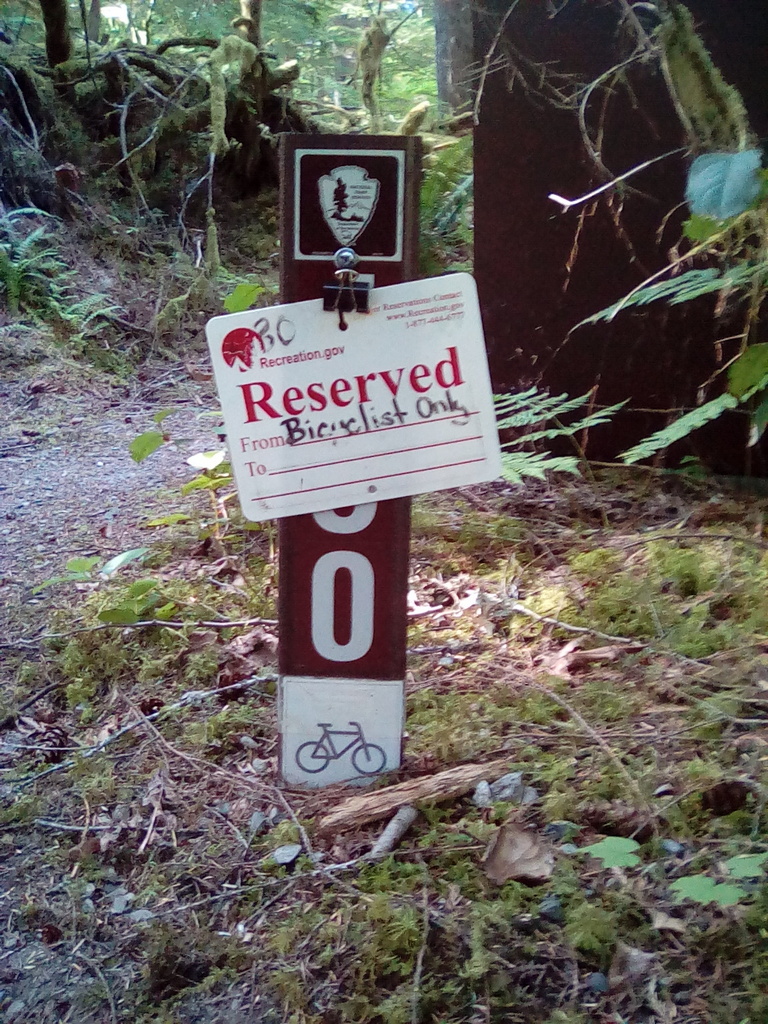
Perfect! Plus, there is a great shower just around the corner!!

39.6 miles.

The climb has begun.

July 8
Pack and leave my campsite at 11:00 AM. I'm taking it easy today and plan to ride only as far as the next campground "Colonial Creek" which is about 12 miles. I'm saving my "juice" for the real "UP" which will start tomorrow!
Newhalem is less than a mile up the road from the campground. It is a company town for Seattle Power and Light. They take care of the dams up river. In town is a museum about the dams and a State Park Kiosk. Across the street from the kiosk is a store for sandwiches and snackage. Three years ago I had biscuits and gravy in the company mess hall but this year the hall is closed. I have an egg salad sandwich and chocolate milk from the store. This is the last opportunity for supplies before Mazama on the other side of the Passes.
Hmmm, what to carry for two days that isn't too heavy? I know, bagels, peanut butter and jelly!!
Onward.
First tunnel. The highway is starting to get steep.

Four years ago Lolli and I camped at Newhalem State Park in our Vanagon. I had my bike with me and decided to check out what it would be like to ride up to the pass. Lolli came driving along about the time I reached the first tunnel and asked if I need a lift. I thought about it for a minute and decided riding in the Volkswagen made a lot more sense than riding a bike up hill in the heat! I didn't even have panniers on the bike. Nope, don't ever tempt me with a free ride up a hill!!
The second tunnel. A lot of gravel along the edges of the road through the tunnels.

I reach Diablo, cross the bridge and do some more up. A nice tailwind helping me along.
I arrive at Colonial Creek CG by 2:30 PM. Another sign saying "Campground FULL" but I look around and find a campsite that is vacant. It is the same campsite I stayed at three years ago but there are a lot of campers this weekend and it seems too easy. I find a Ranger and ask. He says, "The site you are thinking about is reserved. You will find the Hiker/Biker site at the far end of the campground and up the hill".
But of course!!
I ride to the end of the campground, push my bike up the hill and discover the Hiker/Biker site is quite nice. Lots of cool shade on a warm day.... good enough.

After I get set up I hear violins playing an Irish Jig!!

How nice. Much better than a boom box!
11.2 miles.


July 9
Up at 7:00. Packed and rolling by 8:00. Today is the start of the "Big Up".
Out of Colonial Creek, turn right onto the highway, over the bridge and immediately into Granny Gear.
On steep hills I have learned to stop and rest every time my Garmin GPS shows another 100 feet of elevation gain. This gives me time to get my heart back into my chest and regain my breath. Just a couple of minutes of rest makes a big difference and I am ready to climb another 100 feet.
Slow and steady. I have all day!
At an overlook I meet David and his son They are on road bikes. They started in Newhalen this morning and plan to be in Mazama this afternoon. 92 miles with two passes!! No thanks!!
Away they go and I resume my grind, grind, grind.
I bought a water filter at the Outdoor Store before I left on this trip and can top up my bottles from streams and waterfalls along the way. Nothing like fresh, clean and cool snowmelt!!
Grind, grind, grind. I'm averaging four miles per hour but the view is starting to get exciting!

By 2:30 PM I reach the turn-off to my secret Stealth Camp. It is a highway maintenance gravel storage area with a perfect place to set up my tent. I found this spot two years ago and I have been looking forward to it all day!!

The Trillium are in bloom.

23.4 miles

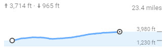
This elevation chart may not look like much but the scale is now in 1,000's instead of 100's.
July 10
Awake at 8:00 AM. A little lazy but cooking breakfast by 8:30. A cup of tea to go with oatmeal, honey and raisins. Yum.
I heard an owl hoot during the night. Nice!
Rolling at 9:30. No rush. Today is the day!
Back to the grind, grind, grind up the last of Rainy Pass.
I arrive at 11:15 AM.

I meet three Pacific Crest "Through Hikers". One takes my photo. They are heading from Canada to Mexico instead of the usual Mexico to Canada because of all the snow dumped in the Sierra's last Winter. They are hoping the trail will melt by the time they get to the High Sierra.
Onward!
Time for a bit of downhill and then the final climb to Washington Pass.
"Look Duckies! Snow!!

We reach the top at 1:10 PM.
For some reason the sign is on the ground!

Oh Boy!! Now the fun begins!!
I am able to coast seven miles at 30~35 miles per hour and then gradually slow to 15 mph as the highway begins to flatten out. Whee!
It took me two days to ride up and an hour and a half to ride down but, keep in mind, I started at sea level in Western Washington and am now around 2,000 feet in Eastern Washington.
Woo Hoo! Mazama!
At the Mazama Store I buy a sandwich, yogurt and chocolate milk and sit at a picnic table in the shade and talk to a guy about my age who has been in the mountains hiking. Interesting guy. Before I head for the Barn Bicycle I buy some bananas and more yogurt. It is warm out and I am not real hungry. The towns are closer together now and I don't need to carry as many supplies.
Back on the road and in seven miles I arrive at the "Barn Bicycle", pull in and set up my kit and caboodle.

I took a rest day here three years ago. This time I meet the owner. He provides camping space inside the barn when it is rainy or out on the lawn if you like. There is a solar or propane on demand shower, composting toilet, small refrigerator with soft drinks and hotplate plus wifi!
It is all free but a donation is appreciated.
It is quite warm. I take a shower, kick back and check my email. An hour later Luke from Donegal, Ireland rolls in.

We eat together and he tells me about his three years teaching English in South Korea!! South Korea was where he got interested in bicycling; "They have great bike trails"! He also taught in Africa!
A very interesting guy and a pleasure to meet him. He is heading for Glacier National Park, then Yellowstone and then Denver where he will catch a flight back home. This is his first time in America and is having a grand time.
It is quite windy this evening but settles down to a nice night.
40.8 miles.


July 11
Luke and I ride to Winthrop for breakfast.

Oh momma, after only oatmeal, honey and raisins for days and days... YUM!
After breakfast we ride on to Twisp.
He is taking the 40 mile alternate around Loop Loop Pass which is closed due to flooding. I turn south onto hwy 153. The rest of this trip will be territory I have not ridden before!!
It is 97 degrees, mostly flat with a slight downgrade off-set with a headwind. Bummer!
I enter Carlton, stop at the gas station and buy chocolate milk. Across the street is a picnic table in the shade. Perfect. Carlton has one gas station, a "Mall" and a dope shop which seems to be busy!!

Back to work. Further on I spot an ice chest and wonder if it is what I think it is?

I circle back and check.
It is!!

Free Ice Water for cyclists!! Awesome! Just what I need. Thank you Trail Angels!
Onward.

Lots of butterflies.
It is getting hot and I'm thinking about finding a stealth camp beside the river. I find a couple of spots that might work and check each one out. The first one slopes too much and the second one had too many rocks and it is too close to the road. Nope and nope.
I'm wondering if I can set up in the middle of an apple orchard, they are all along the river. I find an orchard entrance that is not too close to the farmer's house, roll in amongst the trees and check it out. I am away from the highway but the ground is sloping too much and it smells like it was recently sprayed. Nope.
I'm quite hot and bothered and getting close to Pateros. I check at my Adventure Cycling map and it says, "Camping: City Park winter boat launch, upriver from City Hall on Lakeshore Drive."
Hmmm.
Entering Pateros I spot a Bakery that also does Pizza. I roll in for a cold beer and a 12 inch "Hawaii meets Italy" Pizza "to go". I ask about the City Park and discover is located only two blocks away!!
I grab the Pizza and carefully ride with it over to the City Park and find a nice spot behind City Hall by the boat launch. I have a picnic table all my own, an outlet to charge my "devices" and get this... not only is the camping free but there is even a free shower in the restroom!!
SCORE!!
7:00 PM. Showered, calm, cool and collected I have my kit and caboodle set up and settle down at the picnic table to enjoy my Pizza.

"Whap Whap Whap!!" The lawn sprinklers come on!! My tent, bike and picnic table are within reach of two of the sprinklers!! I skedaddle to the garbage can, grab the lid and cover one sprinkler. Fortunately there is a piece of plywood laying on the ground by the garbage can. I use it to cover the second sprinkler head. YES!!
I wipe off the table and settle into my Pizza. It is a beautiful evening beside the Columbia River.
49.7 miles.


July 12
A nice quiet night at the City Park. I pack and head back to the Bakery for a cinnamon roll and coffee. They have Wi-Fi so I am able to post to the SOB Facebook Page. Leaving town I notice this bench.

All I can say is, "Go Nannies!!"

90 degrees and windy is the theme of this day.
Twenty miles and I turn off for Lake Chelan. Looking back I say bye-bye to the Columbia River for now

I discover I have some bars on my cell phone and since it is "debrief", 11:45, I call the SOB's and discover they are having a Hot Dog Party at the picnic table at the south end of the Noyo Headland bike trail!! I get to say hi to each and every one of them!!
Back to work.
Riding along I hear a "Ping!" Hmmm. Sounds like I broke a spoke. I check and sure enough. The rear wheel has the first spoke I have ever broken. Adventure Cycling shows there is a bike shop in Chelan. No worries.
I arrive in Chelan, have a mocha and enter the address for the bike shop my Garmin Edge Navigator. Hmmm, I am directed five miles out of town, up a hill and through a lot of road repair. Not a lot of fun on a hot day but I finally arrive and it is now a Cross Fit! The nice lady tells me the bike shop closed a year and a half ago, that's the bad news. The good news.... she fills my water bottles with cold water.
Back thorough town and north along the lake.
Duckie spots a buddy.

It is a ten mile ride alongside the lake to the Lake Chelan State Park but I see interesting things along the way.

This is a sad monument. A school bus went off the road into the lake in 1945 and all the children and driver drown.

Evidently the memory lives on.
I arrive at the campground. No hiker/biker site but I am able to find a somewhat shady spot for my tent beside a small tree. $12.00. The shower is half a mile away. The shower requires State Park tokens, two for a dollar, which I have to buy from the Rangette.

But, over by the restroom there is a nice view of the lake.

32.2 miles


July 13
62 degrees at 7:30 AM.
I decide to take a rest day. Tea and oatmeal for breakfast. Lounge around and read my Kindle. Take another shower! I discover Wi-Fi across the road at the restaurant so I catch up on my emails. In the afternoon I draw a postcard sketch for the SOB's.

I charge my devices, (Garmin Edge GPS, Kindle and Amazon Fire Tablet. Dine at the restaurant and call it a day. I have a rather steep climb facing me in the morning.
0.0 miles of riding but a lot of walking.
July 14
Up at 6:00AM. Packed and rolling by 7:00. I am facing 1,000 feet of climbing to get to the top of the Navarre Coolie. Up I go with a final look back at Lake Chelan.

Over the top and a nice fast ride down the Coolie. I stop and put on my wind jacket because it is only 54 degrees!! The road is well shaded in the Coolie. I see houses here and there but I can't imagine living here because of the short amount of sunshine this canyon receives each day. Winters must be brutal!
His and her business?

Back to the highway and the Columbia River.

Into the sun and sagebrush, heading for Wenatchee.
Interesting sign.

Don't look Duckies, Road kill. I put some Mardi Gras beads on it.

I meet this couple riding a tandem.

She is sixty-five, he is seventy. They are from New Hampshire and heading for the Pacific Coast! They tell me they stopped at a truck scale and weighed themselves and their kit and caboodle.
Four hundred pounds!!
Riding beside the Columbia

which is backed up by the Rocky Reach Dam.

I arrive on the outskirts of Wenatchee and find the "Wenatchee River Confluence" State Park. The Rangette in the kiosk informs me she can not assign me a tent site yet because there is a group of seventy-six coming in. None of the group of seventy-six have arrived yet so she doesn't know where she can put me. I ask when she will know? Well, not until the Ranger returns, he is at a meeting. When will he return? 4:00 PM. It is currently 2:30 PM. Hmmmm.
I roll my kit and caboodle over into the shade, read my Kindle and wait.
4:00 PM arrives so I roll back over to the kiosk. The Rangette is gone but a guy is now manning the booth. I ask him if he is the Ranger. No. The Ranger is at a meeting. When will the Ranger be back. Probably around 5:00 PM.
That's enough of that. The afternoon temperature is now over one hundred degrees. I decide to press on towards Monitor and Cashmere. Heading west out of town on HWY 2, directly into the afternoon sun reflecting from the blacktop shoulder, the Bike thermometer is now

My Adventure Cycling Map doesn't show any campground in Monitor or Cashmere. Oh boy! I can probably stealth camp but I sure could use a shower.
Rolling into Cashmere I spot the "59er Diner". Air conditioned! Ahhh!

Interesting place!
I have a caesar salad and lots of ice water. I'm beginning to feel better!
I find the city park, no camping, but there is a display sign showing the streets of Cashmere and the location of various business. Up in the right hand corner I notice a tent symbol at the County Fairgrounds! Hmmmm.
Back on the road I ride out of town and up the hill to the Fairgrounds. It looks locked up but as I turn the corner I spot a RV trailer park. I roll in and stop at the Host trailer, knock on the door and ask about a place to tent camp. No problem, set up whereever you want! It is $14.00 per night and the shower is free!!
SCORE!!

Oh man, am I ready for a shower!!
40.7 miles.


July 15
Up at 6:00 AM with sun in my eyes!!
I pack my kit and caboodle and roll back into Cashmere looking for breakfast.
It is a smoky morning. I find a bakery, latte, breakfast type place called Weeds. Good coffee and breakfast sandwich but the floor is what caught my attention. The floor is covered with 114,972 pennies and three dimes!! It took the owners 13 months to construct the 42 panels, each panel is three feet by five feet. Each panel weighs 75 pounds. The pennies and three dimes are coated with three coats of Marine Grade epoxy for a safe and durable surface!

I leave this interesting town

and ride west on Hwy 2 which is the highway heading to Stevens Pass.
Wide shoulders and a lot of traffic.
I reach the turnoff onto Hwy 97 for Blewett Pass. There is a fruit stand beside the road so I stop and buy a basket of cherries. In about 13 miles there should be a turnoff onto the Old Blewett Pass Road.

Lots of traffic , wide shoulders and up, up, up. I decide to eat one cherry each time I stop to catch my breath. I eat a lot of cherries!
I notice a roadside information sign about Blewett and stop for photos.


Onward.
At 10 miles I see a turn-off onto the Old Blewett Pass Road but according to my Adventure Cycling Map it is too soon, the map says I have three more miles to go. I keep rolling uphill, eating cherries and after four more miles and no turn-off, the day getting hot and no shade I decide to turn around and coast back down to the turn-off I saw at 10 miles. By golly, it was the right turn-off ! I am now on a narrow blacktop road with very little traffic, plenty of shade and soon spot a perfect streamside spot to set up!

I even find a heart rock for my Lolli!! This photo will have to do because it weighs about four pounds and I am not adding it to my kit and caboodle!

30.2 miles


July 16
A very nice night beside this stream. I enjoy the peaceful white noise.
A lazy breakfast and pack up and I'm back on the road.
Old Blewett Pass Road requires a steady granny gear and I take 100 foot elevation breaks and even some 50 foot elevation breaks and slowly work my way up. Very quiet, lots of shade, some birds and no traffic!
Two cyclists pass me doing their day ride. They don't have time to stop and talk.
I reach the top. No sign indicating the pass but the road starts down so, this must be it! The pass is 4,071 feet according to Adventure Cycling.

Now the fun part. Down and down.
I want to stop somewhere before Old Blewett Pass Road reconnects with the New Blewett Pass Road. Sure enough, as I get close to that highway I discover another nice spot beside a stream! It even has an old truck seat with no covering, just springs, to set on! I use my Z-pad for a cushion and read my Kindle. Today was a hard but short ride. I'm taking the rest of the day off!

I draw another postcard for the SOB's, my interpretation of riding eastern Washington.

Down at the stream I refill my water bottles using my new filter.

Perfect campsite.

8.85 miles!


July 17
What a surprise, I wake up at 4:00 AM to pee and the temperature is 39 degrees!! I have to add some clothes before I crawl back into my sleeping bag! It was 105 degrees two days ago and now this! Current elevation. 3,100 feet.
Pack and roll. Just before I return to hwy 97 I see another sign about the Old Blewett Highway.

Along Hwy 97 I spot some folks dredging for gold.

My brother has photos of his "Office" when he plays his drums. Here's my "office" when I go touring on my bike!

The Adventure Cycling Map shows a restaurant symbol a few miles ahead but when I arrive the restaurant it is closed! Twenty-six miles to Ellensburg. Time for a Power Bar!
I nice long downhill and Wind Turbines start appearing.


Entering Ellensburg I spot this cool Mobil gas station but as far as I can tell, it is just for show.

I find a restaurant that has Wi-Fi and they build me an Awesome Avocado and Steak Wrap with unlimited ice water. It is, after all, 84 degrees out there.
After Lunch I happen upon the ReCycle Bike Shop. It is a very nice and complete bike shop. They look at my broken spoke but won't be able to replace it until tomorrow. Since the broken spoke isn't giving me any trouble and no more spokes have broken I have decided to press on.
Leaving Ellensburg I eventually end up riding beside the Yakima River. It is getting to be quite a hot afternoon.

The Yakima River enters the Yakima Canyon and it is quite interesting.

I'm thinking about stealth camping but happen upon a BLM campground. Not a lot of shade but I find a place to set up behind a bush.

45.4 miles.


July 18
I went to bed about 8:00 last evening and was surprised the gravel I set my tent and air mattress on was like laying on an electric blanket with the heat on medium high!! It took a while for the heat of the day to dissipate after the sun went down! My only other distraction later at night was two freight trains over on the other side of the river! Somebody needs to oil the wheels! Screech!!
Packing my kit and caboodle I can't find the stuff sack for my tent!! I look all around the campsite but no joy. The wind must have come up during the night and I slept right through it. Oh well.
It is a beautiful day for a bike ride. Perfect temperature and the Yakima River Canyon is a great ride.

Oops! Don't look Duckies!!
I cut off some "Snake Jerky" to mail to the SOB's and place Mardi Gra beads on it.

The train has a nice grade through the Canyon but the highway goes up and down.

I spot these two White Pelicans. Who knew!


Rolling out into the flats I notice Mt. Rainier in the far distance. I'll be heading that way soon!

Near Yakima I am surprised to see this apple orchard has the apple trees wired and ready

for machine picking!! I knew this was done with grapes but apples?

I discover there is a new Rail/Trail between Yakima and Naches called the Yakima Greenway.
Very nice.
They used the original railroad girder bridges.
They used the original railroad girder bridges.

Lots of benches along the way and water fountains that even have a drinking fountain for your dog!

This apple packing plant beside the bikeway sponsored a bench, shade and monument!

They even have streetlights in places!!

I finally reach the intersection I have been looking for; the turn onto hwy 410, the road heading for Chinook Pass and Mt. Rainier.

Up to 94 degrees today and I am pretty whipped when I come upon the Elk Ridge RV Park. I roll in and ask it they have tent sites for bicyclists. They do, 22 dollar a night with free showers.
Sold! I have not had a shower in three days.
My tent site is right beside the American River. There is a nice cool breeze coming down the river.
Excellent!!

49.6 miles.


July 19
I have a nice night beside the river. Melodic white noise and cool breeze. Perfect!
Pack up and roll out and notice this Wedding Gate. Evidently the Elk Ridge RV Park hosts weddings. I notice a grounds keeper and ask her if she will take my photo.
Here's my bike and I getting married!
Till death do us part!!

Roll out onto Hwy 410 and start the climb. Rainy Pass, Washington Pass and Blewett Pass are in the bag..., I recon I can do this one too.
Duckie enjoying the flowers.

Don't look Duckies! This fawn had just been hit, it's eyes had not even started to glaze and there was no blood, no broken legs. It was just laying there like it was asleep but.., it wasn't.
I put some Mardi Gras beads on it's neck.

Up up up. I take frequent breaks. I plan on camping at the last campground before entering Mount Rainier National Park, it will take me a couple of days to get through the park and I don't see any campgrounds in the park along my route.
Gradual up all day but not granny gear worthy.
In the afternoon I stop and read about Tom X. Fife.
"Fife’s Peak is named for Thomas X. Fife. The Fife brothers: Tom, Joseph, Robert, and their father John, emigrants from Fifeshire Scotland, are credited with finding the first nearby quartz gold mine during 1888. The mine is in the Gold Hill area near Chinook Pass. Tom Fife would trek to his mine following 'X' blazes on trees (there were no roads) and remain in the hills until December each year, when supplies ran out and hunger got the best of him. Tom homesteaded at Goose Prairie, near Bumping Lake. Camp Fife, the Boy Scout Camp at Goose Prairie, is named for Tom Fife as he willed the land to the Boy Scouts. Never married, Tom was known for his kindness to and love of children. When World War I arrived, Tom made an earnest effort to enlist, but being 65, he was denied. According to Jack Nelson, caretaker of Bumping Dam, when Tom acquired a khaki coat and trousers his joy was boundless for he felt that he was wearing a US soldier's uniform."

I reach the last campground, "LodgePole" Campground. US Forest Service.
Golden Age Passport works!! $9.00!
I set up my kit and caboodle in site #1. It is furthest from the River where all the other campers are located. The only water in camp is provided by an old fashioned hand pump. The water is rusty and tastes like iron. I take my trusty Sawyer water filter over to the American River and fill up my three water bottles with nice cool snowmelt!! Excellent!
I don't need the rain fly; it is such a nice evening. The local chipmunks are the most aggressive chipmunks I have ever encountered. They think the stones I throw at them might be food and chase them!! One started chewing on the bottom of my right front pannier! I put a stop to that! They lose interest and move on to more promising prospects amongst the campers down by the river.

26.4 miles.

This elevation map is shown reversed. I climbed from Elk Ridge to Lodgepole.

July 20
Another great night of sleep, cooler temperature and I didn't need the rain fly. It was a beautiful night looking through the mosquito netting before I fell asleep.
Packed and ready to roll. Here is the pitcher pump. Note the Lodgepole Pines in the background. They are tall and mostly straight

Back to work.
The climb has become serious but it is still doable in granny gear with lots of rest stops.

Ahead, I see the road cut at a steady 6%.

The higher I get the more variety of flowers. Here's some for Ducky.

Oh boy! Snowmelt. Time to refill my water bottles, again!

Looking back, "Goodbye Eastern Washington".

Well, I'm bummed! I arrive at Chinook Pass and it is overcast and drizzling!! This is the only overcast day of my whole trip!

Just beyond Chinook Pass is Tipsoo Lake. This is what I have seen in years pass when I drove over Chinook Pass.

Now I am on a bicycle and I get this!

Oh well, better luck next time!
I have an awesome down, down, down ahead of me. Looking over the edge you can see the road in the lower right corner and more road on down if the far distance after the switchback!

Minutes later I look up at the roadcut where I took the previous photo.

A fast and fun downhill. Soon the drizzle ends as it becomes warmer the lower get.

Another stop for fresh water.

I made it. Flat road at last.

Now the turn off to Stevens Canyon Road and my final up and up.

My Golden Age Passport lets me in for Free!

It is a pretty ride up hill into the canyon and time to start looking for a stealth camp.
Duckies keep a sharp eye out.

Ah! A wide spot in the road where folks pull over to pee. I stop, check it out and there is a small trail. I push my kit and caboodle up the trail past the last of the toilet paper and on up the hill until I find a perfect spot to set up my tent on a bed of moss!

Awesome! "Wild Camping" in MT. Rainier National Park!!
26 miles.

Chinook Pass 5,432 feet the high point. Starting up Steven Canyon to the right.

July 21
My stealth camp worked just fine. Packed and rolling by 9:00 AM.

Smoky but sunny again. Woot!
Look Duckie, we can see Mt. Rainier!!

Yes indeed.

Up and up and up! Mt. Rainier getting closer.

Another tunnel.

This is a pretty amazing road cut into the rock!

Another tunnel.

A couple of road bikes enjoying the downhill ride. Zip, zip!


I continue slowly working my way uphill and can see my future! Switch backs!!

But I am getting closer!

Looking back I can see my past!

Woot!

I'm so glad the clouds went away.

The roadside flowers just get better and better the higher I am.


I reach the high point near Paradise at 4,800 feet and begin the FINAL down, down, down of this trip.
Crossing over the Nisqually River bridge. All the debris is from the Nisqually Glacier!

Looking back. I have left Mount Rainier National park

In a few mile I know I will see the Whittaker mountaineering store and outdoor cafe. Oh boy have I been looking forward to this! I have a mushroom burger with fries, IPA and Wi-Fi!! Woo Hoo! Back in civilization!! I call my Lolli and me brudder and do some e-mail and Facebook.
The hard part of my trip is basically over, all downhill from here, I just need to find a place to camp tonight.
Onward into the late afternoon.
I spot a side road with a sign that says "Horse Camp". Hmmm....
I rolled in and discover a campsite for horse people. There are some folks set up with their motorhomes and horse trailers at different campsites. I rolled my iron steed over to a picnic table and set up. Nobody pays me no nevermind.
Nice!

38.9 miles


July 22
No charge at the horse camp! Perfect!
Pack up my kit, back on the highway and on to Elbe where I have a great breakfast in the Railroad Dinner.

Two eggs, hashbrowns and great sausage paddies and I charge my Garmin.
Back to work but really just an easy downhill grade.
It is amazing how many folks are heading for Mt. Rainier but, it is Saturday after all.
Oh Oh! Don't look Duckies!!
A Red Fox. The first one I have ever seen.

Some Mardi Gras beads and I move on.
Mt. Rainier is becoming Far and Wee.

It is a tight road from Eatonville to Yelm. No shoulders, fast traffic and an occasional asshole. This is the most hazardous section of road the whole trip!!
In Yelm I finally enter the Yelm/Tenino rail/trail and the end of highway riding this trip.
I reach the turn onto the Chehalis/Western rail/trail and call my friend Mason who lives in southeast Olympia near the rail/trail and ask if I can spend the night.
"Come ahead!"
Too much reflection in this photo of the rail/trail network tying three counties together but I turned north at the red dot onto the Chehalis/Western which will take me to the end of my ride at Ed and Suzanne's in north Olympia.

Anyway, I arrive at Mason's and he cooks up a wonderful veggie omelet while I setup my tent.

We have a great conversation but I retire early.


July 23
Back to the rail trail.

It is a great rail/trail.


Near Olympia there is even a bicycle round-about!!

Another seven miles and I arrive at Ed and Suzanne's.

Duckies are very happy to see Ed and Suzanne's pond.
We go out to the local hamburger joint for burgers and beer. Perfect.
July 23
Breakfast, load my bike on and my panniers in their Vanagon and we're off to Camano, Elger Bay, and my Lolli!!
18 days, 35 miles per day average.
18 days, 35 miles per day average.

Time to reflect.
This was an AWESOME trip. Much more fun and interesting than last years ride from Jordan, Montana to Sandusky, Ohio.
Yes, it got hot. Yes it got cold (one night) and yes it was a lot of work uphill and a joy zooming down. I would love to do it again next year with some of my SOB's. It would be a fun time and something we will never forget!
Here's to ya!!

Fantastic Bro. Thanks for taking us all along for the trip we really enjoyed it!!!
ReplyDeleteI'm in for 2018! Hope we get a group of SOBs to join in.
ReplyDeletethis sounds so wonderful - what a great account of it. I would love to do this trip myself one day soon. thanks for recording it all - very enticing.
ReplyDeleteBravo. I envy your ability to find great camping sites. East coast is not camping heaven, I guess.
ReplyDelete