I wake at 6:30. Sort of sunny out although the sun is in the northwest! I sure am turned around!! I crawl out of my tent and see my food bag, pill bottle, tea infuser and bamboo (silverware) set scattered between my bike and the closest bush!! A bit farther on is the plastic bag that held two bananas; the only food I was counting on for breakfast!! Now the bag contains two banana peals! F**king raccoons unzipped my "kitchen" pannier and stole my breakfast!! Fortunately they couldn't get my pill bottle open! Now all I have left for breakfast is tea and trail mix. I sure hope the market in Joyce is open.
Back on the road. I stop to take a photo of the beach and...,
Spot this River Otter making a run for the surf. Cool!
Now, time for the 200 foot climb back up to HWY 112.
While riding along I am learning about local politics.
HWY 112 dips down along the beach for 10 miles or so. At one access point I walk my bike down to pose a shot.
Wild Foxglove is everywhere.
The day is finally getting long in the tooth.
I've only traveled 26.71 miles but I have been on my cell phone to my Lolli and she has decided to drive out and meet me at Neah Bay this Friday. So now I have time on my hands as this is only Wednesday.
At Mile Post 31 (which means I am 31 miles from Neah Bay) I find a "Gated Community" for my camping security.
Pull in, get far enough back to diminish the road noise and set up camp.
Nice!
July 11
At 2:30 last night I was awaken by a very unusual Coyote "Sing". There seemed to be only one coyote making all the noise but I have never heard a coyote sing like that one. It was an almost continuous series of yaps interspersed with a couple high pitched screams. It went on for over five minutes. He was really letting the rest of his gang know all about the interloper, me!!
Cool!
Up, out the gate and on the road by 9:00. No big hurry, I have 34 mile to go to get to Neah Bay and two days to do them. Pedalling along I happen upon the Pysht River and just have to stop and fill my water bottle with Pysht!
Then I use, for the first time, my SteriStick. A small water purifier that uses ultra violet light.
Seems to work. Hard to tell! The water tasted fine and I didn't get the trots later in the day so I guess it did.
Finally, the turn-off to Neah Bay.
Soon I come to Clallam Bay, then Mid Point and then Sekiu. I have lunch at the only restaurant in Mid Point.
About six or seven miles further on I see a small trail down onto the beach. I park the bike and walk down to take a look. The beach is a nice crescent shaped beach about a mile long. Around to the right, beyond some driftwood and up against the bank I find a small flat ledge where someone obviously had camped with a tent. Well hey! Looks perfect to me!
I unload my panniers and carry them down, return and then squeeze my bike down the narrow trail and carry it around to my new camp (I don't want to get sand on the tires and then on the chain etc.)
Soon camp is set up and I kick back and watch cruise ships sail by!
All afternoon not a soul walks "my" beach except me.
Is this perfect, or what!
The tide comes within 20 feet of my tent during the night. Wonderful "white noise" of slapping waves.
20.67 miles. Easy peasy!
July 12
Taken from my notes:
"I had a beautiful wake-up this morning. The sun was shining on my tent. There was sunshine on my tent last evening too but during the day it was in the shade!
I had gathered firewood but skipped having an evening fire and laid down instead and watched the sunset out the tent flap. The sun finally set around 8:30 and I was almost asleep when I heard a car arrive up above and soon some voices. Well, that got my inner "mom" going real good with all sorts of scenarios and with the breaking waves there were additional sounds that fit right into my imagination! People walking around and what not while I am hunkered down, trapped in my sleeping bag and tent, so I can't see what is going on!!
Am I going to be beat to a pulp in my sleeping bag by baseball bats? (Thanks for the idea Easy Rider!)
Finally I hear the car start and leave. Whew!
Finally I have to stop "listening" and just let the shore break become white noise.
Finally I sleep."
Breakfast on a drift wood board.
It is another beautiful day and it is time to pack up and hit the road.
Hooray hooray, today's the day.
I'll see my Lolli in Neah Bay!
What a beautiful and interesting coastline.
And even bicycle riding entertainment!!
The road striping crew passed this way yesterday and they didn't bother to sweep off the sticks and twigs. I was hoping to see a flattened beer can or rodent striped but it didn't happen.
Riding a bike I am able to stop when I see a perfect photo opportunity. If I were in my Vanagon I would have had to keep driving because there are no "pull-outs".
I arrive at the boundary of the reservation. Only seven miles to go.
I stop at the museum, talk to the attendant and get the lay of the land. Next stop the "Warmhouse Restaurant". I am hungry and have no trouble putting away Eggs Benedict and two cups of coffee. By now it is almost noon and time to look for a motel room. Linda's Woodfired Pizza is recommended because "she has some nice room upstairs". I ride to Linda's but nope, she is full. She recommends another place and I ride over to it. Nope. Full. They recommend "The Cove". I ride to The Cove but they too are full, all rooms taken; "Opening weekend of King Salmon season", but they do have a tent site for $18.00.
I take it.
But my tent is a one person tent. Oh boy!
I call Lolli. She is on her way and just nearing Port Angeles. I tell her about "no room at the Inn" and ask if she wants to skip coming out to Neah Bay.
"No way! "I will pick up a sleeping bag and pad at a thrift shop and we can sleep in the back of my Subaru Outback!!"
She thinks she should arrive around dinner time so I tell her about the Warmhouse Restaurant. She will meet me there.
Nothing to do but wander around a gawk at things.
There is a large marina and I walk out and look at the boats.
Most of them are fishing boats but one catches my eye.
It is a beautiful small sailboat.
I go up to take a closer look and get invited aboard.
I soon discover "Bill" designed and built this 26 foot Ketch. He and his wife sailed for 10 years in a "plastic" 32 foot Sloop and after that he knew what he wanted in a boat. It took him "Eleven Winters" to build this one. The hull is build of vertical grain red cedar, double tongue and grooved, cinched with stainless nails and glassed inside and out. The lead keel can be raised and lowered. Every detail is perfect and all built by him.
He trailered it to Neah Bay for "sea trials".
What a treat to visit and see his artistry.
Back to my tent site at The Cove for a shower and then over to the restaurant to await Lolli.
She arrives and we have a nice dinner, drive over to the marina and watch the sun set and then set up our bedroom in her Outback. Perfect!.
Nightie-night
July 13
Up at 7:30. A quiet peaceful night. Sleeping in the car wasn't all that bad but we are not getting any younger! Lolli hit the shower while I packed and put my bike and panniers in Lolli's car. Then off to the restaurant for breakfast and coffee.
Next stop, we drive to the end of the road and hike on out to the Northwest tip of the United States! Cape Flattery!
We gawk around
read the signs.
It is beautiful now but I bet the Pacific Storms are wild when they hit.
Now back into town and a visit to what Lolli was most interested in seeing, the Makah Indian Museum.
It is a spectacular Museum containing much of what was found at the
Ozette Village which was covered by a mud slide in 1560. All well preserved and very nicely displayed. Well worth the visit.
Plus, there is "Fish on a Stick" Salmon filet's being smoked and cooked by dry Alder wood.
Yum!!
We enjoyed our Salmon lunch and then it was time for Lolli to get going. She is heading for her friend Margaret in Seattle. I decided, since I had already ridden the road out to Neah Bay, it would not be a big biking sin to snag a ride back to the the turn-off to Neah Bay where I would catch HWY 113 heading south to HWY 101.
AND, since the turn-off is where the start up Deadman Hill is located, why not have Lolli drop me off at the TOP of Deadman Hill. That way I won't have to worry about it any more!!
Cheating, I know but hey, I only missed out on six miles of up!!
It is already 3:00 in the afternoon when Lolli drops me off at a "Gated Community"...,
I walk the bike far enough in to get away from the highway noise, found a flat spot and called it good.
Back at it tomorrow.
July 14
8:30 AM. Packed up and leaving the "Gated Community"!!
I had a good night's sleep.
When I woke up I wondered what the temperature was because it seemed like it had been a warm night. My bike computer displays not only miles traveled, total miles traveled, altitude and time, it also shows temperature!
So I take a look and..., it is missing! Damn!
It must have fallen off when I had the bike on its side in the back of Lolli's Subaru.
I can live without it but it was nice to have.
So I'm pushing the bike from my campsite to the gate and there it is, laying in the weeds!! I could have so easily been looking a different direction and walked right by it.
Amazing! Bike magic!!
HWY 113 to HWY 101 cuts across the tip of the Olympic Pennisula from the Strait to the Pacific Ocean so it is warmer and less breezy for a while.
Nice.
A lot of clearcuts and "plantations"
I take the turn-off HWY 101 to visit La Push.
It is a fourteen mile ride out to the ocean on a "Memorial" Highway!
And road kills, this was a big female elk! I wonder what the vehicle looked like.
Typical small town target practice.
But lush. All the flowers are really popping.
I'm away from Forks and their vampires and entering the reservation.
I find another $18.00 tent site at this RV park. Coin operated showers.
But one hell of a view!
In the evening I have a nice salmon dinner with the works.
Walking back to my campsite I pass the woodworking school.
There is one new canoe made with the laminated wood and glass method
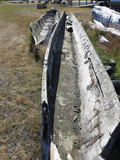
And some worn out ones carved out of single cedar logs.
Home sweet home.
33.09 miles. Nighty-nite.
July 15
A lazy get-up to a beautiful morning.
Evidently La Push is a favorite surfing location.
Can you spot the surfer setting in this root wad checking out the surf?
I'm undecided what to do today. Pay another night or move on.
I added up the remaining miles to our friends, Ed and Suzanne. About 200 miles.
About a week if I average 30 miles a day. Lolli is planning to attend a Petanque Tournament in Portland next weekend and if I time it right, she could pick me up on her way back to her cabin.
11:20. Decision made. I'm moving on.
I stop by the grocery store to buy a Gatorade to help power me up the hill, top off my water bottles, then push my loaded bike up the steep driveway to the road.
I see some people waiting at a bus stop and one is a woman with a loaded touring bike! She says the bus is due. I think about that long hill I rode down yesterday to get to La Push. Seems silly to ride back up it when the bus will be here any minute!!
I whip off the panniers and am ready to load as the bus pulls up. No charge!!
Back up at the intersection of Memorial Highway and 101 the driver drops me off at the bus barn.
I pedal two miles to Forks but pass right on through, no vampires for me.
Six miles further on I happen upon Bogachiel State Park. $12.00.
1:40 in the afternoon. 78 degrees.
Only 8.17 miles today but, good enough.
This is one of the cleanest, best taken care of State Parks I have visited and,
No graffiti!!
July 16
To bed at 7:00. Up at 7:00!
The log trucks started rolling at 3:15 AM!
There were mosquitoes when I arrived yesterday but they seem to be sleeping in this morning.
I'm doing an early start this morning. I have a hill coming up and I want to get over it before the day warms up.
Most of the time I am riding in a corridor of trees but now and then I get a view of the Olympics.
Lots of tree farms, plantations, clear-cuts.
And a lot of closed businesses.
Tough times for the critters too.
Nobody home but it looks like it is still active. Out back there is a nice greenhouse and the tomatoes are in full production.
I borrow three! They were excellent!
Hey!!! After ten days I have finally arrive!!
HWY 101 swings back along the ocean again and I stop and look south.
North.
And straight out at "Destruction Island".
According to Wikipedia:
The
Hoh Indians used to frequent Destruction Island to capture
rhinoceros auklets. In recent years the population of Rhinoceros Auklet have been in decline as a result of the predator activities of non-native European rabbits.
Destruction Island was used as an anchorage by Spanish ships in 1775. A crew of seven men was sent to the mainland to procure supplies of wood and water, but was massacred by the local Indians, leading naval lieutenant
Juan Francisco de la Bodega y Quadra to name it the Isla de Dolores (the
Island of Sorrows).
] Twelve years later, Captain
Charles William Barkley, an independent English fur trader, arrived in the ship
Imperial Eagle, and sent a party ashore from the island to a similar fate. He named the river where the second massacre took place the
Destruction River. Captain
George Vancouver later transferred the name to the Isla de Dolores when the river was given its Indian name, the
Hoh River.
Three shipwrecks occurred at the island in 1889: Cassanora Adams, Port Gordon, and Wide West. The 94 foot Destruction Island Lighthouse was built on Destruction Island in 1888-91. A US Coast Guard detachment operated the lighthouse from 1939 to the early 1970s. The light was automated in 1968, before it was shut off for good in April 2008. The island itself is accessible only by boat.
Continuing on I happen upon a road sign that says "Big Tree" with an arrow indicating the tree is .3 miles "that-a-way". So, I decide to check it out.
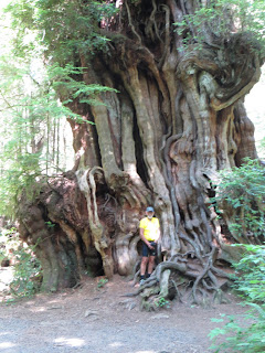
Here it is! The "Big Tree" happens to be a Cedar Tree. The reason it was left standing was because it was too deformed to be marketable.
12:50 I arrive at the Kalaloch Lodge and guess what? It has clouded over!
No idea what it means but I know I have been very lucky to have had 10 days of perfect weather.
I lock my bike in the provided bike rack and enter the Kalaloch Lodge. The waitress has no idea what the weather is going to be but does bring me excellent fish and chips.
After lunch I visit the Kalalock Market and buy a few items. I ask the clerk about the weather. She says it might rain, "We get
twelve feet of rain a year you know".
TWELVE FEET!!!
Holy Cow!
Back on the bike and onward.
In three miles I come upon "South Beach State Park". $10.00 for a campsite, first come, first served. The place is almost full. I find a table and campfire ring back against the bluff near the outhouse. Good enough!
I get the tent set up and start blowing up my air mattress. A little kid in the campsite across the way is trying to open the back hatch on their SUV. It is locked so he runs to his mom and bugs her for the keys. I'm sitting here watching this activity while continuing to blow up my air mattress. Finally they get the car unlocked and the kid runs around to the back hatch, gets it open, hops in and rummages amongst their camping gear. Finally he hops out and comes running over to me carrying a Coleman box. Inside is an air mattress pump! Too late kid. I just finished!!
But what a nice gesture from a young kid.
And then it starts to rain. I crawl inside and take a nap.
Rain over I crawl back out and walk out on the beach.
Nice.
Back in camp I see some folks from Holland have arrived with their "Made in Holland" tent!
I know because they gave me the grand tour. Nice folks.
Hard to tell from this perspective but my one person tent is minuscule compared to their Taj Mahal!
35.5 miles today.
Night-y night!
July 17
Up at 7:05 and on the road by 7:45!
Hey!! Some SOB (No, not you SOB's), some SOB took my tooth brush! It was a nice new blue tooth brush I bought in Neah Bay! I had it in one of the loops on my handlebar bag. It must have gotten ripped off while I was enjoying my fish and chips yesterday. That bike rack I had my bike locked to was in a rather heavily trafficked tourist area. I'm sure my little air pump buddy and the folks from Holland would not stoop so low.
Bummer.
Back to the tree corridor.
And the clear cuts.
And the abandoned mill sites.
And the trash.
and the abandoned sawdust burner.
And then...,
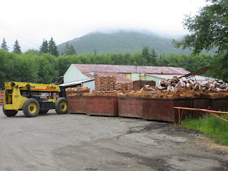
A functioning Cedar Shake Mill.
I see the owner driving a fork truck and ask him if I can take a look,
"No Problem" and we walk inside to check it out. Quite noisy and the workers are really hopping to stay ahead of the automated splitter: sorting into stacks according to grade and size.
Next up, Lake Quinault. Just not that inviting on an overcast day.
This is as close as I get.
Stopped at Amamda Park Restaurant where I have a nice Avocado, Bacon Cheeseburger w/fries.
Yummy!
This warm, muggy weather has caused me to really sweat my down sleeping bag. I am thinking about finding a laundry so I can wash and dry it but the closest laundry is 6 miles, round trip, off route and "they don't have soap" says the lady in the market. The only soap the market has is full sized boxes and jugs. Nope.
I know washing a down bag is not a good idea but it is a mummy bag and it is now damp and clingy when I roll over and it gets real claustrophobic feeling in the middle of the night. It is driving me nuts.
Bing!!
I just remembered...! I brought along my silk bag liner!! I decide to put my air mattress inside it and then sleep on the silk liner and use the down bag, unzipped, as a quilt!
No more overheating in the bag and no more claustrophobia!!
Duh!
Onward.
Mid afternoon and I start looking for a "Gated Community".
I like my "plantations" not too tall, (shade equals mosquitoes) and not too short, (windy and too sunny) if the sun is out. Nope, I like my "Plantation" to be, "Just Right". Open but not too open with a nice breeze to keep the mosquitoes away.
I slide my bike under the logging gate and ride about a quarter mile away from the road noise.
Perfect!
44.83 miles.
July 18
Up and at 'em by 7:50.
Slowly.
I always thought solo bicycle touring with all the days pedalling along the road would give me plenty of time to think creative thoughts, make up stories, mentally invent stuff but no. It seems all my blood is being use by my heart, lungs and legs with very little left over for thinking. Mostly I pedal along with my mind caught up with either counting pedal strokes to the top of a hill or trying to remember stuff, on the flats, while I avoid broken glass and shredded tires.
For some reason, several days ago, I started trying to remember the name of a fancy car; no, not the Roll Royce, not the Bentley. That other high end sedan. I knew I knew its name but I could not bring it up.
This morning, suddenly, bingo. Maybach!
Strange.
And then I happen upon something like this.
A perfectly straight road for miles and..., wham!
What were they doing? Why did it happen at this spot?
So sad.
And then, the various signs of patriotism.
I think about the war memorials I have seen in various small towns.
It is amazing the disproportionate number of "people to town size" that have died in wars.
Neah Bay for example.
I wish I had taken a photo of the plaque on their Memorial Stone.
It looked something like this:
There were more names listed under "Peacetime" than any other war!!
How would you like to be listed under "Peacetime"!
But, when you live in a small town where the only choice is logging or military....
Every small market and gas station around here has "recruiter" posters in the windows. Logging isn't hiring much anymore but the military sure is.
Well, anyway.
It is a somber day for riding. Cool, overcast, light breeze, birdsong. Robins, hummers and the bird that goes; Wheet? Wheet? Wheet?
(Pete Gealey tells me it is a Swainson Thrush)
There is helicopter logging going on in the distance. I can see it making trips to various logging sites, the choker setters try to keep up.
I pull into Humptulips and Whoot!
A fellow bicycle tourist!! Steven just finished his tour in the Army. This is his first bike trip. He is riding a Surly Long Haul Trucker just like mine!! He left Port Angeles a couple of days ago and is headed for San Diego. His butt hurts.
I know the feeling!
I talk him into posing for a "Silly Shot".
He heads on down HWY 101 and I look for my turn-off onto Yountman Road. Gonna start heading east towards Olympia.
Yountman road is a county road and has some Oddities!!
A very nicely done mail box holder.
And then I arrive at an intersection where I am supposed to turn onto Wishkah road.
(I'm following my Adventure Cycling Map, or trying to.)
A "feller buncher" goes by.
Deer keep an eye on me.
At the Wishkah/Wynoochee intersection I turn left and soon see a "no outlet" sign.
Oh boy! That's not right!!
I flag down a couple good ol' boys in their pick-up and tell them I am trying to get to Elma.
They tell me I am going the wrong way and give me the correct directions.
Soon I am back in agreement with my map and see that I have a four hundred foot hill to get over before I get to Elma.
It takes a while but I finally make it and then down, down, down into farming country.
I try to find the last "Gated Community" before I am out of the woods and into the flats that are farmed and fenced but, no joy.
I figure I am only a mile or two from Elma and running out of stealth site possibilities when...
There it is, a wee gravel road going down and around behind a bush! I can see no one has used this road in a long time, even for a potty stop. It is only 20 feet from the highway but, it'll do!
39.94 miles and the sun is back!
Sunshine makes me happy!
July 19
7:30. Overcast and light mist. I didn't put the rain fly on last evening so stuff is damp.
I have good cell coverage so I talk to Lolli and then Ed. The plan now is I ride to Tenino and then take the rail/trail out of Tenino and intercept the Chehallis/Western rail/trail that goes to Ed's house. I should arrive at Ed's Saturday and Lolli will arrive Saturday night. We will stay the night and then Lolli will haul me and my bike back to Camano Island.
Now then.
Where is Elma?
I hit the road and ride the remaining one mile to Elma but it is not there! Instead there is a big highway intersection, cloverleaf deal. Highway 12 and 410. It is overcast and I don't know which way is north or even east for that matter.
I see some guys at a Schwan's Ice Cream distributorship working on a truck, ride over and ask them where Elma is. They point out the right direction but tell me it is another eleven miles! Beans! I was hoping for breakfast.
Onward.
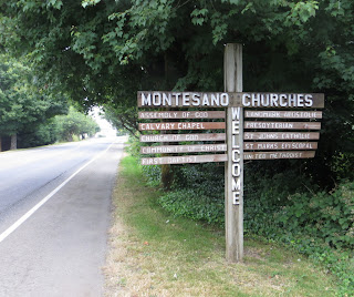
In a few miles I start to enter the town of Montesano.
Looks like they got religion pretty well covered!
There's the Busy Bee Restaurant and I park like the big boys do.
Inside it is an old time cafe! Peggy Sue playing on the Wurlitzer, lots of old timey signs and memorabilia. And, REAL breakfast!
Perfect!
Turns out Montesano is hosting a classic car show this weekend; several hundred hot rods and classics are going to show up. It seems Montesano is host to a lot of classic car gatherings and there are a lot of stores and shops aimed at that market.
Even old timey bicycles!
The street through Montesano is the highway and it is an old timey highway, Washington 410.
Montesano reminds me very much of Waitsburg in Eastern Washington and particularly, Freemont, Nebraska where I lived when little.
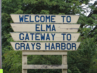
Ten miles later, guess what?
Yippee!! although I have no intention of going to Grays Harbor.
Elma has a church too. Trust in God but propane is nice!
They even have bike lanes.
But enough about Elma.
This is where I leave Adventure Cycling Association Washington Parks map Section 1 and start following Section 2, the route towards Mt. Rainier.
The sun comes out and I peddle past this road kill barn owl. Beautiful bird. Bummer.
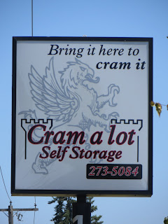
On the outskirts of Rochester I happen upon "Cram a lot". Cool!
And then Trail Magic #2 happens.
I'm stopped, looking at my map and trying to figure out which road to take when up pulls a white Vanagon bus. I had waved at a white Vanagon bus a bit earlier; I wave at all Vanagons.
Anyway, out pops Pete and Mary, our good friends from Fort Bragg!! They had gotten tired of hammering up Interstate 5 and had decided to take an off ramp, on the spur of the moment, and enjoy a lesser road. And there I am!
But you think that's cool, last year Lolli and I were in a coffee shop in Port Townsend and in walks Pete and Mary!! Amazing!
I will see them again at the cabin next week.
So, onward. There it is! Mt. Rainier!!
It is probably a better idea for these girls to produce fiber than hamburger!
My first bull frog road kill.
And then, Trail magic #3.
The day is warm and there is a long uphill stretch. I finally reach the top and pull over beside a shady tree to catch my breath and have some water when I spot my blue tooth brush laying on the ground beside the tree!!
What are the odds??
Well, it isn't really MY blue tooth brush but once I wash it real with Dr. Bronner's, it'll do!! :-)
Finally, Tenino!
I pull up to a latte stand and order a smoothie. I ask the lady if there is somewhere around here I can pitch my tent for the night. She gives me directions to the City Park. She tells me the STP (Seattle to Portland bike ride) came through here last weekend and people camped all over the park, she is sure my one tent won't be a problem.
Perfect!
52.83 miles. My longest ride of the trip.
July 20
This is it. Only about thirty miles to Ed and Suzanne's and all of it on former railroads road beds converted to hiking and biking trails! Nice!
I zip back into Tenino for breakfast at the one and only restaurant; avocado, tomato and bacon omelet. Excellent!
Then, back to the start of the rail/trail.
Wonderful riding. No traffic, no road kill.
Signage about former towns along the way.
Sometimes I can see forever!!
At seven miles I reach the turn-off onto the Chehalis, Western rail/trail to Olympia.
Less than 21 miles to go.
Hidden dangers? Could it be things that go bump in the night??
Now and then active rails beside former rails.
Embiggen this image to see what a great idea was accomplished.
Well, okay. One road kill.
The view from the bike lane over Interstate 5. Roaring madness for a few moments and then back to the peaceful bike trail.
And finally, the end of the line. Ed and Suzanne's. This photo taken from their deck.
30.82 miles. A wonderful ride. For the first time I rode the last 30 miles wearing ear buds listening to 88.5 FM KPLU. Since it was Saturday I listened to Car Talk, followed by This American Life followed by Radio Lab. Excellent!
The miles flew by.
Lolli will arrive this evening.
Back to the cabin on Elger Bay tomorrow.
417 miles in 14 days.
I'm thinking about trying the North Cascade Highway next. Lolli said she would drive the Vanagon as Sag Wagon. Hmmmm.
Stay tuned!


