June 15th. Day 27. I'm back in the saddle again.


Looking east up the Columbia River. Where I'm heading doesn't look good. But, oh well, it is a warm rain!
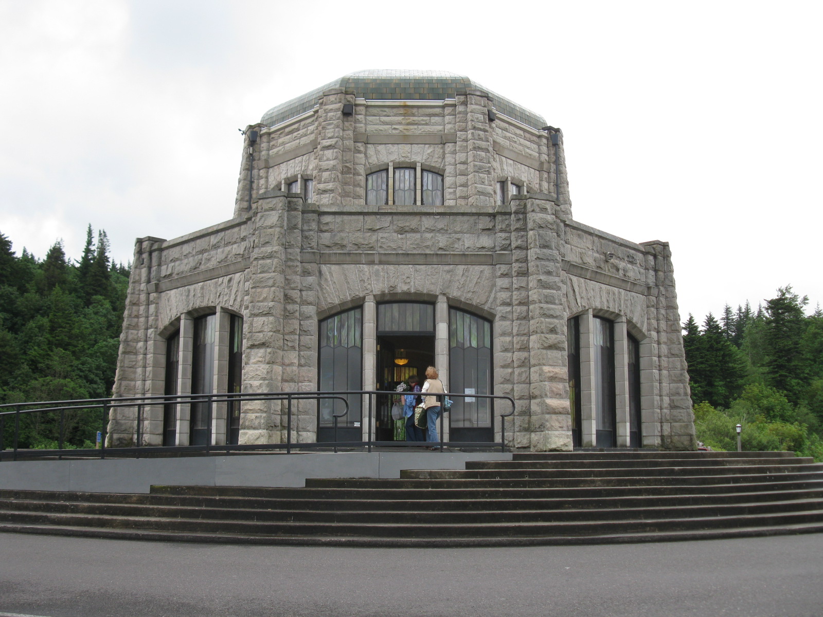
The amazing Vista House at Crown Point! It was built to showcase Highway 30 back in the "good old days". Some lady volunteers are setting up a table with cookies and coffee for visitors but unfortunately they will not start handing it out until 10:00. Because I am anxious about the weather I decide to press on. No cookies for me.

Looking up at the ceiling of Vista House. Quite remarkable.

On the steps looking down river towards Portland.

Looking up river towards what, I hope, will eventually be the dryer side of Washington State. It doesn't look promising.

But rain means "lush" and one hundred varieties of green!

Old masonry railings edge the many bridges along Historic 30. Moss is abundant.
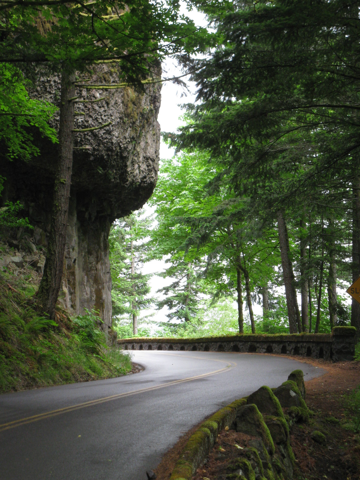
This highway is a remarkable feat of early road building through difficult terrain. There is very little traffic this early in the season so it is a very pleasant ride.

Bridal Veil Falls, one of many waterfalls along the way. I think it would be more spectacular on a hot sunny day!

Wikipedia:
"The original highway was promoted by lawyer and entrepreneur Sam Hill and engineer Samuel C. Lancaster, to be modeled after the great scenic roads of Europe. From the very beginning, the roadway was envisioned not just as means of traveling by the then popular Model T, but designed with an elegance that took full advantage of all the natural beauty along the route.
When the United States highway system was officially established in 1926, the highway became the part of U.S. Route 30. Since then, modern Interstate 84 has been built parallel to the highway between Portland and The Dalles, replacing it as the main travel route and resulting in the loss of some of the original sections of road."

Ho Hum. Another waterfall.

I-84 down below.

This is an area where a section of Highway 30 slipped out. These steps provide a way for bicyclists and pedestrians to continue. Note the "groove" provided to help guide bike wheels during accent or decent. I removed my panniers to make the bike lighter and easier to handle down the steep grade.

Soon I am back on the old highway. A lot of artistic masonry went into this old road.

Along with the wonderful Highway 30 and greenness there are slugs! But notice the dry ground! Yes!! After riding 26.65 miles I am closer to Eastern Washington and have arrived at Herman Creek Campground.
I have to push my bike up the hill to the campground but hey, it isn't raining!! This is a very small campground with only 9 campsites. I walk around and check the sites out and finally settle for #1 because of the view of the Columbia River and some log rafts.

The fee is five dollars for those with a Golden Age Pass. Hey! I got one of those but this is the very first time I have ever used it! Cool!

After I get my tent up and stuff spread out to dry a fellow cycling tourist shows up.

Eric from Michigan! He is 20 years old and heading for Portland to see his girlfriend "who is no longer there"! He gives me directions on what to do after Biggs when old HWY 30 dumps me out onto Interstate 84. "Cross over to Maryhill, Washington. Take HWY 14 east to the Umatilla Bridge, cross back over the Columbia and get on HWY 12 East."
I carefully write this down since my Historic HWY 30 map quit at Biggs.
Because Eric will arrive in Portland tomorrow he loans me his Adventure Cycling Maps of Idaho and Montana! He also gives me his half empty container of Bull Frog sunblock SPF 36, "You're gonna need it!".
I can't wait!!!
We talk until 10:30PM! Nice guy!
June 16th. Day 28.
Eric is outta here and I hit the road too.

What's this! It looks like I am going to be out from under the cloud pretty soon!

Oh my yes! Sunshine!! I have to ride alongside Interstate 84 for a ways but I don't mind. Good weather is just ahead!

I stop at Starvation Creek State Park and roadside rest area and talk to a guy who is on a road trip with his Harley Davidson. I wonder why I sold my Harley Davidson, travel was so much easier then. But then too, I wouldn't notice the lava formations, stop to admire the flowers, listen to the birds, see all the broken glass and bungee cords along the roadside.
I leave the rest area and resume riding the breakdown lane of I-84. In about fifteen minutes I hear a "beep beep"; the guy on the Harley roars by giving me the "low hand" sign. Cool!
Nine more miles takes me to the off-ramp to Hood River. The first thing I notice; Hood River is a hillside town! I never noticed these things when riding my Harley!
I find the main part of town and start looking for a bike shop. I'm hoping to buy an Adventure Cycle map that will get me to Idaho. The bike shop guy recommends a guy down the street who owns Anthony's Pizza, "He does all kinds of bike touring."
I walk my bike to Anthony's Pizza. It is a really neat restaurant with open windows out onto the street. I ask the waitress about the owner "who is into biking". She tells me to "just go up those stairs". Up I go and am welcomed into Anthony's office. We have a great talk about bicycle touring with me picking his brain and then he draws a map on a piece of paper showing how to get from Biggs to Clarkston on the Idaho border. He warns that "groceries and water will be a problem along highway 14".
Back down in the restaurant I order a pizza "wrap" with spicy chicken. Sit by the open window where I can keep an eye on my bike and watch all the pretty people walk by. Excellent!

Leaving Hood River via the old highway there is an immediate climb of switchbacks. I have discovered Interstate 84 is straight, level and crazy busy with semis, motor homes and people in a hurry. Old Highway 30 is up and down and up and down with California Poppies!! Sunshine!! Peace and quiet. No contest!

Once past the "burbs" of Hood River I suddenly see barriers in the road. I'm thinking, oh no, not after all those switchbacks but as I get closer I see they just stop car traffic. This is the Senator Mark O. Hatfield West Trailhead! There is a nice little park for people to park their car, get out, stretch and then continue either on bikes or walking. Perfect!
I like Hood River. A very health conscience town and I didn't even mention wind surfer heaven!

Great views of the river along this path.

Approaching the Mosier Twin Tunnels. Check out that sky!!!

Mosier Twin Tunnels.

Arriving in the small town of Moser. I stop at the market to buy tortillas, peanut butter and a can of spaghetti and meat balls.


I also buy a nice cold bottle of chocolate protein drink, walk across the street, and sit on the picnic table looking at this totem pole. It is quite different from most totems I have seen. Very intricately carved.

Next up, Memaloose Overlook. Then down, down, down and, up, up, up to Rowena Pass.

Starting down from Rowena Pass the headwind is so strong I'm almost knocked over several times. Chubasco style winds that slam me all of a sudden when coming around an exposed point.
According to my map it is 12 miles to The Dalles. My map doesn't show any campground between here and there so I better start looking for some place to stealth camp before I get down on the flats. The switchbacks overlooking the river are very windy, the switchbacks against the hills are quite sheltered. I finally find a sheltered turn with a small parking area and a trail going up the hill. I park my bike and hike up the trail for a look. I have to walk about fifty feet to get past all the toilet paper and about another block before I find a level enough area for my tent. The spot just big enough. Back to my bike to push it up the hill.

There is poison oak everywhere. I am very careful choosing a site for the tent, I don't want poison oak transferred onto me when I roll up the tent in the morning.
Good new / bad news..., no rain fly needed but, there are a lot of mosquitoes.

Home sweet home, my sleeping bag drying out.
After my dinner of spaghetti and meatballs I am lying on my down sleeping bag listening to NPR. Since it is still warm out I am nude. Suddenly a guy goes zooming by on a dirt bike! He takes a quick glance and keeps going. I lay there wondering if this will become the movie, "Deliverance" or "Easy Rider"!
Finally gets dark. I don't hear anything. Guess not.
June 17th. Day 29.

Peanut Butter and tortilla. Breakfast of Champions! Pack up and leave my stealth camp after a, thankfully, non-eventful night!

Back on the last section of HWY 30. I'm not flagging down traffic. I'm gronking the sun and scenery!! Oh happy, Happy, WARM morning! No wind. Perfect!!

The end of a good thing.

Riding the breakdown lane of Interstate 84. I stop in some shade for a break and WOW! What is that? Mount Hood? I hadn't noticed it in my bicycle mirror.

The Dalles Dam. I take the exit to visit the dam but homeland security will not let me get close enough to even see it. "You need to park your bike and sign up for the tour bus ride." Nope. No thanks.

Back on the Interstate one of these blow by now and then. I finally figure out they are hauling sections of towers for windmills. Pretty interesting how the section they are hauling is the only structure between the tractor and the rear end of the rig. No trailer!

I still can't get over eastern Oregon/Washington weather. After all the rain, this is wonderful although, I must admit, Bull Frog sunblock is becoming quite necessary.

Ten miles beyond The Dalles I see this railroad bridge across the Columbia. Two freight trains are tied up waiting for a barge to pass under the bridge. I stop and watch the action for a while. Finally the movable section of the bridge is lowered and the trains start rolling again.

A huge windmill blade just passed me! I have been trying to get a photo of one but they are always by me and down the road before I can get to a full stop and get my camera out of the handle bar bag. Frustrating.

I pull off for lunch in a shaded roadside park. I'm enjoying watching the river go by when I suddenly heard a loud "POP-swish"! A car club has arrived in the park on their way to some car show and all their cars have some sort of air suspension system they release when they park their car or truck and it settles on the ground!

Strange! I guess they are the opposite of "jacked up" pickups!

Back on the road. There is a nice section of frontage road allowing me to ride beside I-84. Every now and then there is a roadside shrine.

And Sagebrush!! Oh man, my first sagebrush!! I stop and rub some into my biking gloves to smell and I take a few sprigs to adorn my handle bar bag. I love the smell of sagebrush.

Ah! There's one!
30 miles. I arrive in Biggs, Junction. Biggs Junction, Oregon. The day is, for me, getting hot! Biggs is a jammed packed truck stop, gas station, fast food, mini market four-way stop. Full of hot and bothered drivers, whiny kids and disaffected teenagers all waiting in lines for gas and fast food. I park at the MacDonalds and walk inside to order a Hot Fudge Sunday. It takes forty five minutes!! If I didn't want my treat so bad I would leave in disgust except, well, for the air conditioning!!
Across the street I spot a small mini-mart and take my life in my hands trying to get to it between big rigs, motor homes, and SUV's! I buy some salami, bagels and more spaghetti and meatballs.
Now, it is time to face the bridge.

A wikipedia photo.
This is where I cross over to Washington State to get to HWY 14 East. The bridge is old, only two lane, with a very narrow, almost nonexistent, bike lane. Of course the late afternoon wind is blowing 30 miles per hour, across the bridge, up river. Oh momma!I make it almost to the high point of the bridge where the girder bridge section begins when I see in my helmet mirror a big semi tractor-trailer rig coming up behind me. Of course there is a semi tractor-trailer rig coming the other way too!! I squeeze over as close to the bridge railing as I can get when my front pannier suddenly snags on the curb twisting my handle bars to the right into the railing! I grab the rail to keep from dumping over into the road just as both trucks roars by. Maybe I am over emphasizing this a bit but not really, it scared the shit out of me!!
The trucks are gone, I mentally regroup, sort myself out and coast the rest of the way into Maryhill State Park. Whew!

Nice park. $12.00 Hiker/Biker. Welcome Washington but, oh well.
I set up in an area that turns out to be, "NOT the hiker/biker area". Oops! Pack up and walk my bike and gear over to my new, correct, campsite. Get set up, walk to the shower, wash myself and my clothes. Back to camp, string up my cloths line, hang my cloths, and kick back! Ahhh!!

Off in the distance I see the start of tomorrow's ride. Up, and up, and up to HWY 14. Oh goodie, something to worry about while I try to sleep. Also, according to my map, it is an 80 mile ride to the next town, Umatilla and, remembering Anthony's advice, "No services until you get to Umatilla".
For dinner I have spaghetti with meatballs and the last of my salami chopped up as extender.
I settled into my tent for a well deserved rest, soon busy counting sheep when suddenly my eyes pop open. It is 10:00 PM and I am sick to my stomach!! I swallow hard several times trying to mentally will myself well but soon realize there is only one way this will pass, I have to get to the restroom NOW! I unzip the tent and do a hasty two step through the dark towards the "Day Use" restroom; I really don't want an audience when my schist hits the shan. I arrive not a moment too soon and discover the door locked!
Nothing for it but to hoppity skip to the other "Campground" restroom about one block away. I am really, really, on the verge of losing it when I slam my way into a stall in the men's. E-gad, that was close!
Greatly relieved and subdued I stagger back to my tent and fall into bed. It must have been that several day old salami and no refrigeration.
I start stressing about tomorrows eighty mile ride with minimal supplies, an empty stomach and cleaned out large and small intestine! I really should ride back to the mini market in Biggs Junction in the morning to buy some extra food but I can not face crossing that bridge across the Columbia two more times. Nothing for it but to try and get some sleep and deal with what happens as it happens.
June 18th. Day 30.
I wake to light drizzle. Oh boy!

Pack up, roll out, and pedal up and up, up, up the grade to HWY 14. Take a break to look back to where I was.

Up on HWY 14 I see signs for the Stonehenge structure at Mary Hill but the road to it is even more up and I have had enough. No. Time to bicycle east; lenticular clouds in my future.

Just as Anthony said. Nothing for 80 miles. Oh boy!

This is sad to see. A straight road, minimal traffic. What a singular spot to cease existence in such a vast location.

And then there are these. The end result of all the long loads I saw on Interstate 84.

The sky becomes more ominous and it starts to sprinkle again but as they say, "It is a warm rain".

Another damn dam on the Mighty Columbia.

The dam probably powered this aluminum smelting plant which is now in ruin and slowly being disassembled. Large pieces of metal siding are banging in the wind as I pedal by.

The light rain ends with a wind squall and the weather starts to improve.

Check out my bike computer! 2,235 total miles! 1,235 training miles before I left Fort Bragg and 1,000 into "Ronnie's 70th Adventure"!
And then, what's this? Roosevelt! Roosevelt, Washington! A very small glitch in the road where there is a mini mart with an OPEN sign! Inside I find a great selection of food items for the bicycling traveler. The woman behind the counter even has a bike log so I can sign in! She said, "The oldest cyclist to log in was 86, the youngest was 8, riding with his dad on a tandem".
While I enjoy a sandwich and chocolate milk two more bicycle travelers arrive. They are young guys heading east but I am sure at a faster pace than I.

I refill my water bottles, buy some extra snackage and press on. The wind has become a nice tailwind and I make good speed as the weather gradually improves.

Now and then I come upon one of these. Cell tower? Homeland Security? Aliens?

After sixty miles I decide to call it a day. This is the longest time I have spent in the saddle in one day and my butt hurts. Looking for a stealth camp isn't easy in this wide open country but eventually I come upon a small side road that ends in some brush between the highway and the railroad tracks. I park my bike and walk around looking for a level spot for my tent. Oops! A pile of deer carcasses. I realize this is where highway maintenance dumps road kill!
I find a spot upwind from the dead deer for the tent, get it partly staked down and discover red ants starting to run all over the tent! Oops! Ant hill!!

One more move. The final location is not as level as I had hoped but it will have to do. It is hard to heat my Dinty Moore Beef Stew in the wind but finally dinner is over, I am settled in, the wind subsides, some birds start their evening song and stars come out. All in all, I will have to call this, "A Pretty Good Day".

Pack up, roll out, and pedal up and up, up, up the grade to HWY 14. Take a break to look back to where I was.

Up on HWY 14 I see signs for the Stonehenge structure at Mary Hill but the road to it is even more up and I have had enough. No. Time to bicycle east; lenticular clouds in my future.

Just as Anthony said. Nothing for 80 miles. Oh boy!

This is sad to see. A straight road, minimal traffic. What a singular spot to cease existence in such a vast location.

And then there are these. The end result of all the long loads I saw on Interstate 84.

The sky becomes more ominous and it starts to sprinkle again but as they say, "It is a warm rain".

Another damn dam on the Mighty Columbia.

The dam probably powered this aluminum smelting plant which is now in ruin and slowly being disassembled. Large pieces of metal siding are banging in the wind as I pedal by.

The light rain ends with a wind squall and the weather starts to improve.

Check out my bike computer! 2,235 total miles! 1,235 training miles before I left Fort Bragg and 1,000 into "Ronnie's 70th Adventure"!
And then, what's this? Roosevelt! Roosevelt, Washington! A very small glitch in the road where there is a mini mart with an OPEN sign! Inside I find a great selection of food items for the bicycling traveler. The woman behind the counter even has a bike log so I can sign in! She said, "The oldest cyclist to log in was 86, the youngest was 8, riding with his dad on a tandem".
While I enjoy a sandwich and chocolate milk two more bicycle travelers arrive. They are young guys heading east but I am sure at a faster pace than I.

I refill my water bottles, buy some extra snackage and press on. The wind has become a nice tailwind and I make good speed as the weather gradually improves.

Now and then I come upon one of these. Cell tower? Homeland Security? Aliens?

After sixty miles I decide to call it a day. This is the longest time I have spent in the saddle in one day and my butt hurts. Looking for a stealth camp isn't easy in this wide open country but eventually I come upon a small side road that ends in some brush between the highway and the railroad tracks. I park my bike and walk around looking for a level spot for my tent. Oops! A pile of deer carcasses. I realize this is where highway maintenance dumps road kill!
I find a spot upwind from the dead deer for the tent, get it partly staked down and discover red ants starting to run all over the tent! Oops! Ant hill!!

June 19th. Day 31.

Up and ready to roll. A sunny day! I'm a happy guy!

I was told about a "shortcut" off of HWY 14. Christy Road. I would turn off onto it several miles before reaching the Umatilla Bridge. Christy Road is a nice two lane blacktop road just like HWY 14 but with even less traffic. Riding along I pass a fenced area with tumble weeds piled to the top and just over the top of the tumble weed I thought I spotted something that looked rather colorful and nylon-ish! I stopped, turned around, pedalled back and sure enough, it is the stealth camp of the the two young guys I met at the Roosevelt Mini-Market! We exchanged "Good Morning" and I pressed on.

I am definitely entering different country.

I was told there is a bike lane over the bridge starting at the end of Christy Road. Sure enough, there it is. The bike path leads off into a large culvert type tunnel below the bridge access. I ride through and come out into the sunlight between the bridges. The path turns into a gravel trail and seemed to end. Huh?
I turn around, ride back through the tunnel and decide I must have to ride up to HWY 14 and then find the bike lane. I peddled up the hill to 14, take the exit for HWY 395 onto the bridge and started riding towards the bridge but then come upon a "Bicycle Exit" sign! I take the bike exit and end up riding right back down to where I started, the end of Christy Road!! Beans!
Once again I ride up hill to HWY 14 and this time I stayed on the bridge even though there obviously isn't a bike lane and continue on across the bridge with HWY 395 traffic hammering beside me!


Stop for a photo opportunity midway across.
Turns out there are two bridges side by side and it is the second, more modern bridge that has the bike lane. If I had continued on the gravel path I would have ended up on the proper bike lane across the Umatilla Bridge!

Down off the bridge, around, back under the bridge and to a quiet secondary road that leads me to this nice quiet park. Perfect!
I'm enjoying some early snackage and notice families and more families arrive and claim picnic tables. It finally dawns on me that today is Father's Day. I check my cell phone reception, have plenty of bars and call my two sons and one son in law to wish them a happy Father's Day.

Back to the daily grind I continue on the frontage road which soon comes to an end and I have to climb the grade up to highway 730 and ride past the McNary Dam.

I am definitely in Eastern Washington now. It has become a very warm day with a nice tail wind.

Mid afternoon I happen upon a nice shady tree alongside the river and take a break.
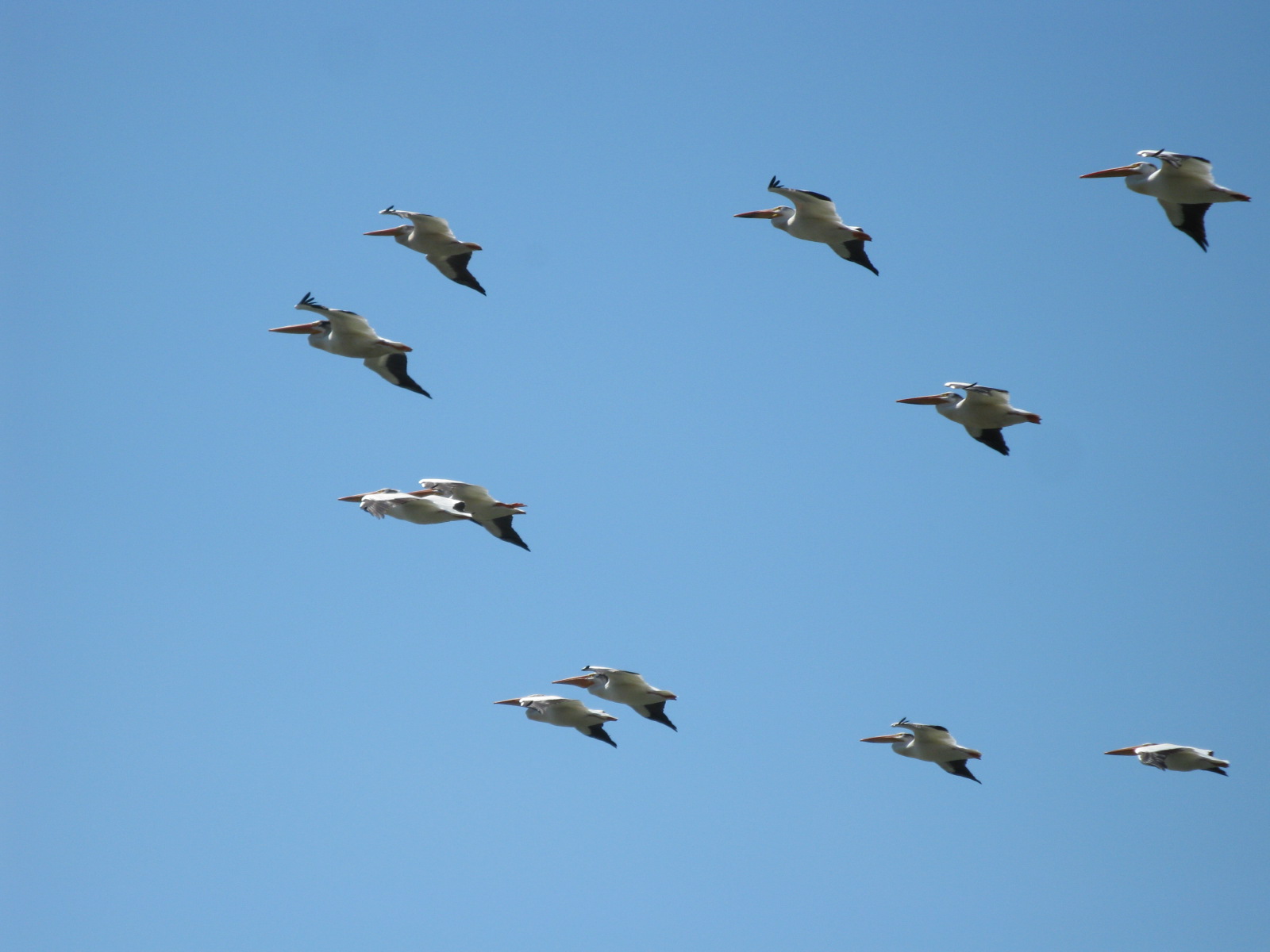
Flocks of white pelicans cruise magically into the wind!

Almost to my exit onto Hwy 12 I notice this para-sail.

Getting closer I see there are two people out zooming around on surfboards using sails for power. They really zip along.

Highway 730 wraps around this geographical feature and I stop to check it out.

Late afternoon and forty seven miles I find this small Army Corp of Engineer campground. There is no charge but also there is no toilet paper in the restroom, no water faucets that work, trash bins overflowing, a constant dry wind that makes setting up the tent tricky and, I soon discover, ticks!!

But hey!! It'll do!
continue
No comments:
Post a Comment